Part One: Joining up the Dots
For pandemic reasons, the 2020 summer solstice sunrise gathering at Stonehenge was cancelled . The awesome sight of the rising sun over the Heel stone in line with the monument’s axis and the ‘avenue’ was replaced by an important discovery: A huge ring of very deep and very wide pits had been discovered in the chalky subsoil around Durrington Walls, just two miles northeast of Stonehenge and a little north of Woodhenge.
The discovery of these pits is of great significance, and came in the form of a report of an on-going investigation report, the result of years of work by large team of archaeologists from many universities, and other specialists.
Due to the site’s proximity to Stonehenge – which is just under three miles to the southwest of Durrington Walls, the PR guys clearly thought it a good time to announce the launch at the summer solstice. The Guardian clearly thought so, coming on strong with this catchy title,
” Vast neolithic circle of deep shafts found near Stonehenge : prehistoric structure spanning 1.2 miles in diameter is masterpiece of engineering, say archaeologists.”
Is this just journalistic hyperbole, or are we being introduced to new evidence that can truly confer a better understanding of the culture that built Stonehenge? I believe that it can, and this article begins a process of making the importance of this discovery accessible to non-specialists and prehistorians alike.
This project was co-ordinated and directed by professor Vincent Gaffney, Anniversary Chair in Landscape Archaeology at the University of Bradford, and the co-principal investigator of the Stonehenge Hidden Landscape project, an overarching programme which has for some years been surveying thousands of hectares of landscape all across Salisbury Plain.
Professor Gaffney’s report delivers an excellent outcome, and offers a new approach to evaluating prehistoric cultures. The various equipments employed in the project shout modernity, taking the reader way beyond the pick and spade of traditional digs. To facilitate this discovery involved the futuristically named Winkie vibracorer and the Dando Terrier percussive corer, ground radar and fluxgate radiometers! More Dr Who than Flinders Petrie.
Gaffney announced:
“We are starting to see things we could never see through standard archaeology, things we could not imagine”.. and..
“The size of the shafts and circuit surrounding Durrington Walls is currently unique. It demonstrates the significance of Durrington Walls Henge, the complexity of the monumental structures within the Stonehenge landscape, and the capacity and desire of Neolithic communities to record their cosmological belief systems in ways, and at a scale, that we had never previously anticipated.” and again ..
“Archaeologists are now joining the dots and seeing this massive pattern.“
I was also much encouraged by the mention of the phrase “cosmological belief systems” and the announcement that, not before time, “archaeologists are now joining up the dots and seeing this massive pattern.” This was music to my ears, for if pattern there is, then this implies a design, an underlying geometrical process and, with it, preferred unit or units of length. This embraces my area of research. So, encouraged by reading Gaffney’s comments on the discovery, I decided to take a closer peek at this new find of ‘wonderful things‘ so near to Stonehenge. I read the report from top to bottom.
My own research work at ancient sites and within their wider landscapes relies on basic surveying skills, and a working knowledge of astronomy, geometry and metrology. This collection of disciplines – my professional ‘skill-set’ is labelled megalithic science within archaeology. It is the kind of stuff that someone with a background in the number sciences is naturally comfortable with, and unfortunately, these subjects remain unpopular within the training and practice of mainstream archaeologists.
Joining up the Dots
A 10 metre deep hole that is 20 metres wide is not best described as a dot, but these are huge holes within a huge landscape design. Holes are very under-rated, a ruined site of fallen and missing stones may well only reveal its original design after the cavities or holes that once held stones are included in the site plan. Far from being a lost stone or post, these ‘dots on the landscape’ present a researcher with one outstanding advantage: while stone or post holes can be destroyed their remaining socket holes are almost immoveable, and the blessing here is that such cavities can usually be assumed to be located in their original, intended position, prior to being filled with a megalith or large post. Remanent holes are of great assistance in allowing the original design of a monument to be recovered.
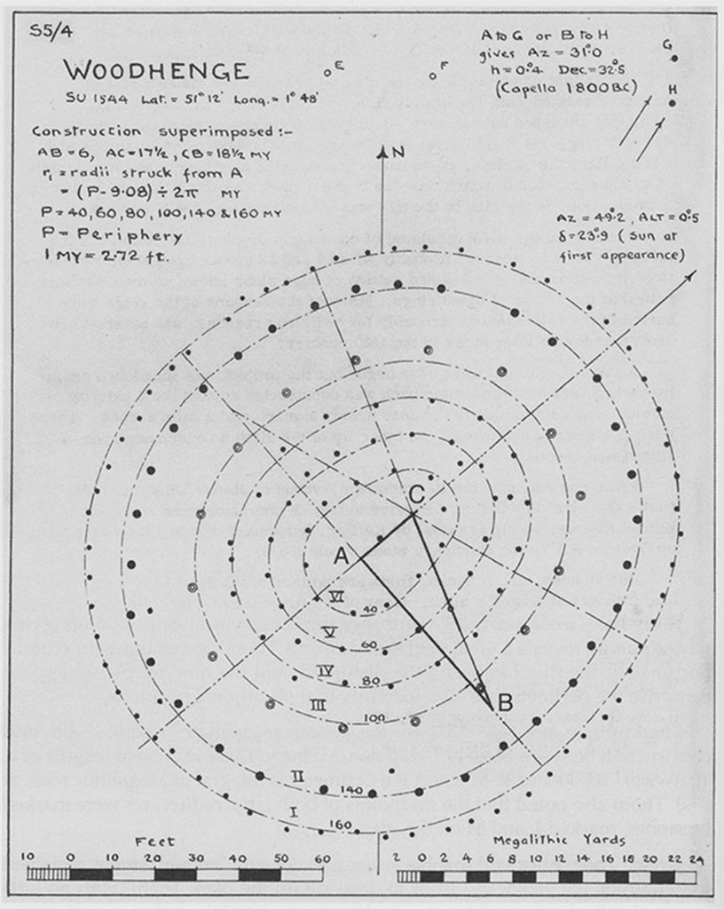
Avebury and Woodhenge are two obvious examples of this phenomenon of site recovery from what were once holes dug to locate wooden posts or stones. When Welsh archaeologist Maude Cunningham first surveyed the Woodhenge site during the late 1920s, it was mainly large concentric rings of holes she uncovered, yet these revealed a first glimpse of this neglected site’s once magnificent past.
Looking at the Woodhenge site today, from ground level (Fig. One), all one sees is a seemingly chaotic pile of concrete markers, each marking where a post hole had once been dug by the builders of Woodhenge.
It was a photograph taken from the air that originally revealed the almost invisible ruin that Woodhenge had become. The Cunningham’s survey then revealed that the site had been constructed to a very obvious and complex geometrical pattern (see Fig. One, below).
Fig One. Woodhenge.
(survey plan via Eoghan MacColl)
Ten years later, Alexander Keiller was brave enough to take on Avebury, and it was the remanent holes that enabled him to recover the site’s original form, its geometric layout. The site Keiller took over was a complete shambles, with only eight stones left standing out of about 160 examples. Some of these stones weighed in at 50 tons, and collectively they formed three of the largest known stone rings.
The first quality that stands out about the new Durrington discovery is that, like both Woodhenge and Avebury, it is clearly not a circle. To dig huge and accurately defined shafts deep into chalk is unarguably a skilled operation, but we also know this prehistoric culture could get its circles accurate when it wanted to, as hundreds of stone circles still demonstrate (for example, the sarsen circle at Stonehenge).
If Durrington pit ring is not a circle, then what shape is it, if any? It clearly forms a ring, apparently a raggedly non-circular ring. Why therefore should one assume it’s shape, it’s design, was not also the result of a skilled design process, like the individual pits themselves? Such a grand project would surely be undertaken with some overarching order, some process, a design to link up where these impressive pits needed to be located – in other words, to join up the dots into some recognisable geometrical design?
If so, then it must follow that skilled surveyors and engineers had developed the required skills and mastered the technology to then apply these skills. What a modern researcher into the prehistoric past needs to do is begin learning how to re-create the ‘service manual’ or logbook for the specific site or landscape under investigation and then make that ‘manual’ available to other historians, archaeologists and the public at large! The ‘service manual’ then lays the groundwork for that very different first chapter in future book about the history of science. A new and previously lost heritage can then emerge from the present fog of prehistory.
Using the OS map of the Stonehenge area and Google Earth I joined up the Durrington Pit Ring dots and began to work with the layout of these pits. Something about the resulting shape was familiar to me. In 2016 I had previously surveyed a very similar shape, not 5 miles from my home in the Preseli region of West Wales, a site called Castell Mawr – Big Fort in Welsh.
Castell Mawr – A Visit to The Preseli Hills
Thirty years ago, Castell Mawr was described as being an Iron Age Hill-fort, and tentatively dated to around 800 BC . Then, in the late 1980s, a flurry of archaeological activity took place, and a full survey of the site was undertaken by Mytum and Webster (Sheffield). They rebranded the site as being a henge monument originating during the late Neolithic/early Bronze Age. Since then other archaeologists, including Parker-Pearson (UCL), have looked for evidence of the existence of an alleged missing bluestone circle. This particular archaeological Holy Grail was briefly thought to have been at Castell Mawr, although no evidence for a stone ring has ever been produced.
The size and the location of the flat henge at Castell Mawr is most impressive, at almost 500 ft in diameter it is much larger than the Stonehenge site (around 360 feet ). The site is located on the top of a wide conical hill, with an excellent view of the nearby Bluestone quarries of Carn Menyn silhouetted on the horizon to the right of Foel Drygarn’s characteristic northern slope topped by three large cairns at the summit.
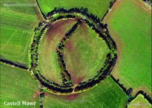
The shape of the Castell Mawr henge is defined by its ditch, shown below (Fig. Two), with its curious internal ‘chevron’ bank on the henge. It is the shape of the surrounding ditch and bank that defines Castell Mawr’s design. Nearly ten feet deep in places, the later digging of the ditch could have destroyed evidence for any earlier ring of large standing stones, yet no evidence for stones having ever been erected on the site has been found.
Fig Two (a). Castell Mawr Henge site (Google Earth)
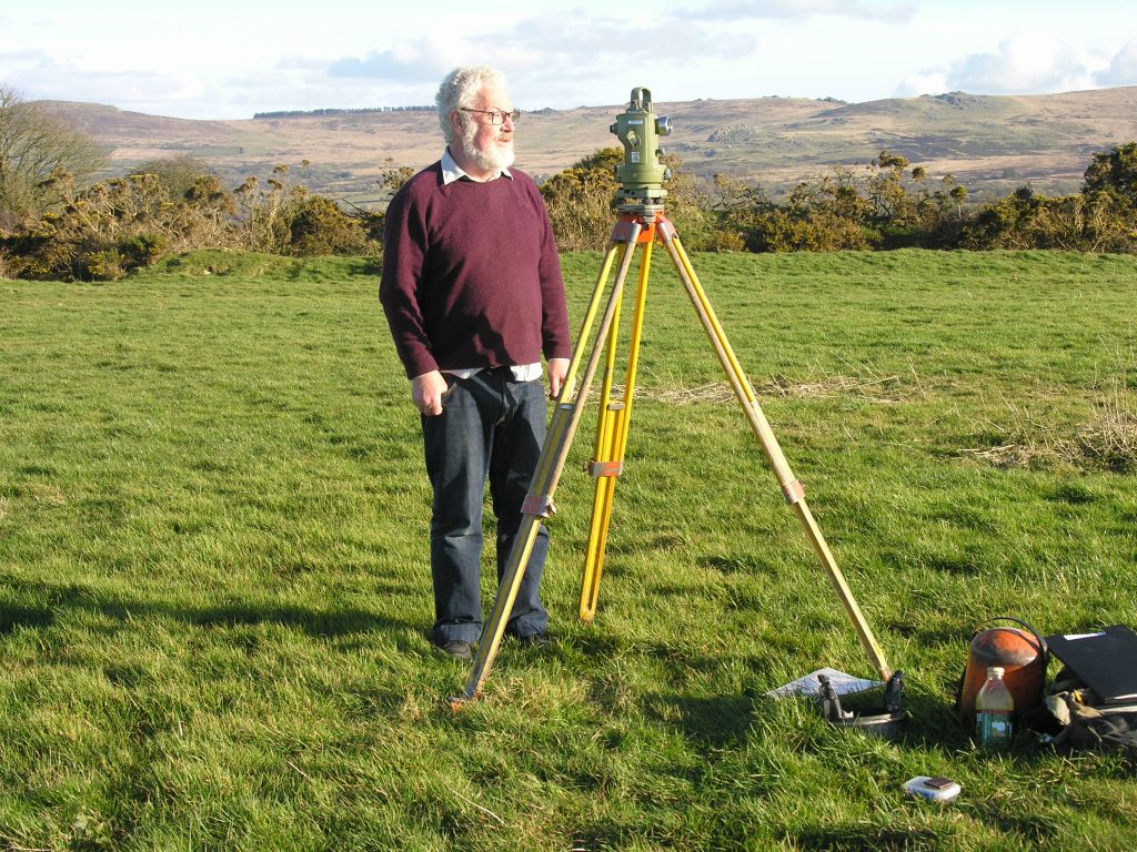
I undertook a theodolite survey of the Castell Mawr site during March and April 2016, primarily to investigate the midwinter sunrise alignment over Foel Drygarn’s cairn summit peak, some three and a half miles distant at an azimuth angle of 134.87 degrees. But I also wanted to investigate Castell Mawr’s geometry and its role within the larger landscape, and this task took a further month to complete. The shape of the ditch, the site’s surrounding boundary, turned out to be a variant of a known type of megalithic construction, referred to as a Type I egg. It’s place and function within the local landscape became a book, Temple in the Hills, available from this website – see category ‘books’ on the MENU bar).
Fig.Two(b). Surveying Castell Mawr henge (Heath, 2016).
The bluestone outcrops of Carn Menyn are visible on the southern horizon, right of the theodolite, while the summit of Foel Drygarn is on the extreme left.
Defining Castell Mawr’s geometry
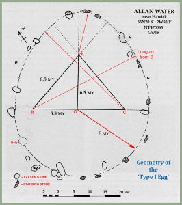
The circumference of the ‘basic’ and relatively common stone ring – the Type I egg design – is obtained from two circles and two long arcs struck from the corners of two right angled triangles, joined back to back along the axis of the design, and often having sides in related integer lengths (Pythagorean triangles, such as the 3, 4, 5 or the 5, 12, 13).
A third arc is struck from apex or ‘sharp end’ of these ‘Siamese’ triangles which acts as the centre of a second, smaller, circle, whose radius is defined by the two points where it first touches the long arcs before they cross on the major axis of this ‘egg’ design (The two long arcs and the two radii are marked in red in Fig. Three, below]. This completes the familiar egg shape. The plan of Allen Water, near Hawick, more easily reveals the constructional process – the design’s geometry – than words can.
Fig Three. Geometry of the Type I Egg .
(basic survey plan via Eoghan MacColl)
Castell Mawr deviates from this more common basic egg design, the larger circle being now replaced by an accurate ellipse, while equilateral triangles are employed to define the radii of the long arcs (Fig. Four, arcs marked in white) and the apex then defines the centre of a second smaller circle that rounds off the ‘sharp end’ of the egg. It must be clear that the construction of this layout would have required long ropes or rods, with stout pegs to mark centres and corners. Careful measurements would have to be applied throughout what was quite some intricate process.
Fig Four. A Plan of Castell Mawr (Heath, 2017)
We are now ready and prepared to establish the required geometrical process that best accounts for the siting and location of the Durrington Walls pit ring.
The Durrington WallS Pit Ring
My next investigation was to ascertain whether there was any similarity or connection between the original design plan or process involved in the placement of Durrington Walls pit ring, and the design of Castell Mawr.
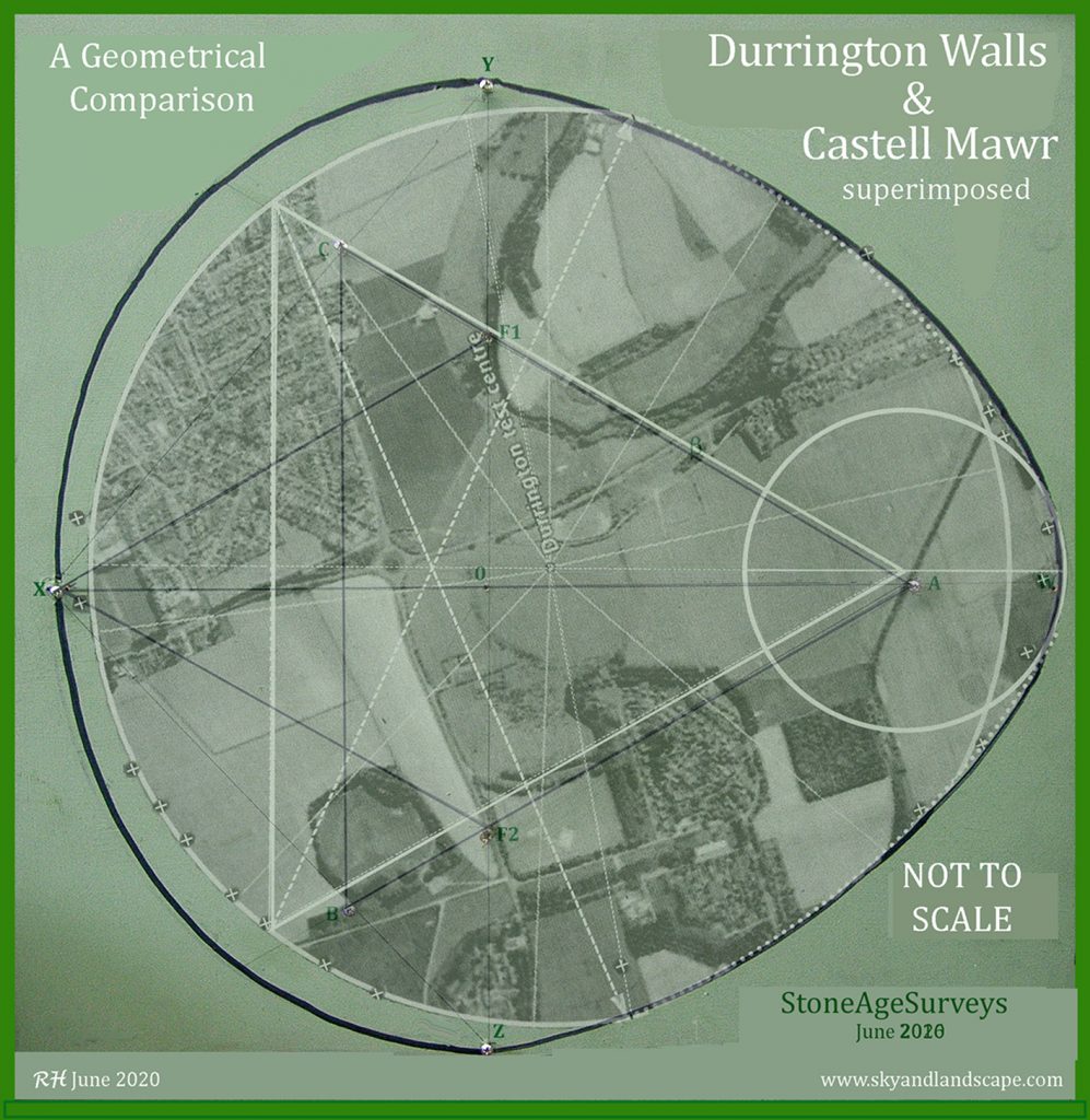
Prior to undertaking this process, the simple act of aligning the major axis of Durrington Walls pit ring with that of Castell Mawr, and then comparing the plans of these two sites, side by side demonstrated how closely the Durrington Walls pit ring’s form and its constructional methodology resembles that of the ditch perimeter geometry at Castell Mawr (see later diagrams). Had the pit ring been based around an an ellipse instead of a circle, as found at Castell Mawr, this similarity of form would have been almost indistinguishable. However, before we can objectify this, the geometry of the Durrington site needs to be revealed – finding a ‘best fit’ for the pit ring.
Any ‘best fit’ geometry (if any) now needs to be established to determine, as exactly as possible, just how closely the two circles resemble each other in their design processes, if at all. Knowing that both rings started life through serious digging and that they have visually symmetrical and similar shape reveals a most interesting picture, but it does not reveal the total picture.
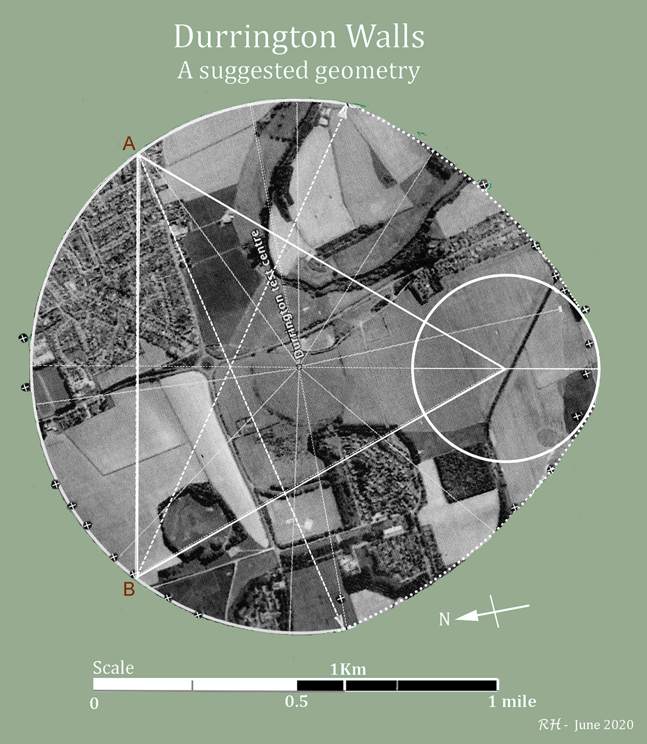 Fig. Five. A suggested Geometry for Durrington Walls Pit Ring.
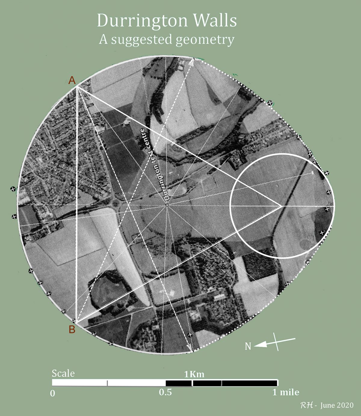
The Durrington pit ring plan is given above (Fig. Five), and it shows a large forming circle, a single equilateral triangle set back from the axis diameter, and two corners that touch the circumference of the circle at A and B. This positioning defines the two long arcs such that they meet the circumference of the circle at an angle of 10 degrees beyond the ring’s minor axis . The third corner of the triangle defines the centre of a smaller circle that rounds out the ‘corner’ where the two arcs meet, on the major axis of the ring.
Each pit is marked on the diagram given in the archaeological report, accurately enough to locate individual pit centres on the plan above (these pits are marked as white crosses against a black circle) and then recover any original geometrical pattern that may have defined the pit’s location – before asking: why they were originally placed where they remain located?
The similarity of form between these two Neolithic monuments is further demonstrated by arranging both plans side by side and aligning the major axes of both sites such that they are aligned ( Fig. Six. Below).
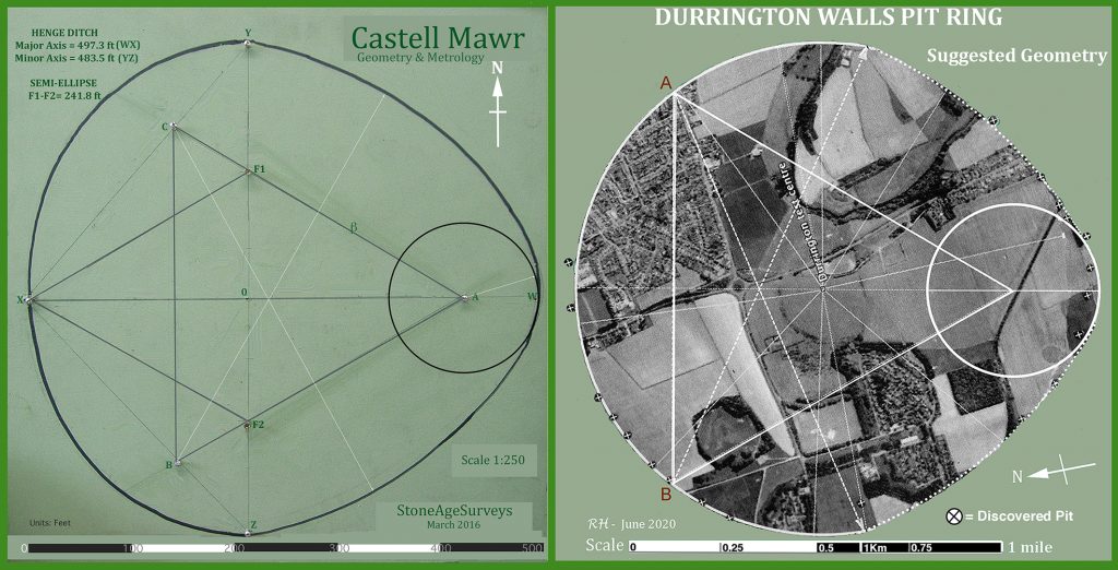
Fig. Six. Comparison of Form. Durrington Walls Pit Ring’s major axis aligned to Castell Mawr. (Heath 2016 & 2020, map from Google Earth)
Suggested Geometry of Durrington Pit Ring
The pits are shown as a white cross within a black circle. Those on the lower left quadrant of the ring conform well to the ‘egg’ geometry, and both long arcs score well, picking up their (few) pit markers. It is only at the ‘sharp’ end, around the smaller circle, (near Halfmoon Clump on the map) where the geometry appears to stray most from the pattern, and the closing arc of the ring appears to have been (somewhat inaccurately) struck from the centre of the forming circle, and then connects with three pits (marked on the official report as 4A, 5A and 6A). Might the large forming circle have once been completed and these pits only dug at the sharp end because they would be serve as a reference in defining the radius of the large forming circle?
Readers can make up their own mind concerning the reality of the above geometrical plans, and their alignment with the locations of the pits. Part Two of this article will study the actual measurements at both sites, from a 1:25000 OS Map, and from Google Earth, and this will further assist in refining the processes of recovery of function and purpose of Durrington Walls pit ring still further, and in turn, this will shed more light on the cultural aspirations of the designers and builders of these two sites.
As a final comparison between these two sites, I rescaled the Durrington plan (Fig. Five above) and superimposed it over the Castell Mawr plan (Fig Seven, below). The resemblance of their functional design processes I found quite remarkable. So let me propose to the reader that, if these two sites were crime scenes involved in a criminal investigation, such a similarity of form, when discovered by a forensic team, would lead them to immediately conclude that the same suspect or group was almost certainly responsible for both locations!
I will conclude Part One of this article by stating what is becoming obvious – the same cultural fingerprints are all over both sites. The first site, in the midst of the Preseli Hills in Pembrokeshire, has an unusually shaped dug ditch ring up to 3m deep into hard Preseli tuff, the second, on Salisbury Plain, sports a collection of huge pits cut deep into Wiltshire chalk downland. The same constructional techniques have been seen to have been employed at both monuments, ipso facto, the cultural toolkit that built these sites appears to be the same. This means that the Stonehenge landscape is found to be connected with the Preseli landscape – now haven’t we heard that before somewhere?
Robin Heath, June 2020
************************************************
End of Part One.
[Part Two is in Preparation, scheduled release around 15th July]
www.skyandlandscape. com www.robinheath.info
email: [email protected]
*************************************************

One thought on “Exploring Durrington Walls Pit Ring”
Comments are closed.