Stonehenge & Woodhenge – A Lost Legacy – PART ONE

  • PART ONE  –   A LOST LEGACY

Soon after the distinguished Welsh archaeologist Maude Cunningham and her husband finished work excavating the site we now know as Woodhenge, in 1929, the locations of each of the site’s many revealed postholes were marked with grey concrete bollards. The best that can be said of this action was that it ensured their original exact positions were recorded for posterity (see Alexander Thom’s photograph below, from 1958, courtesy of Eoghann MacColl).

Visually, Woodhenge is neither a pretty nor an impressive site, unlike its nearest neighbour, Stonehenge, some 1.9 miles to the southwest. VIsitors to Woodhenge tend not to linger around this site, and soon slope off to nearby Durrington Walls, to the north, or Stonehenge, to the southwest. This article claims to lift the present Cinderella status afforded to this Neolithic class II henge and timber circle monument, by identifying a previously unrecognised significance in its geodetic placement with respect to Stonehenge.

Continue reading “Stonehenge & Woodhenge – A Lost Legacy – PART ONE”

Interesting Factoids about Avebury + free PDF download.


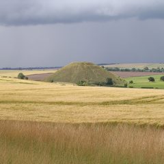
Ten Interesting Factoids about Avebury

1. Avebury is the largest known stone circle anywhere, with a surrounding ditch and bank a mile in circumference

2. The centre of Avebury is placed 4/7ths of the distance between equator and pole, at latitude 360/7*

3. A very detailed and accurate seven station closed traverse survey was undertaken by Professor Alexander Thom in 1978.

4. Thom reported that the perimeter of the outer stone ring was 1302.5 Megalithic yards (MY) of 2.722 feet, which is 3545.4 feet or 520 Megalithic rods ( 1 MR = 2.5 MY).

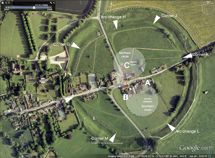
5. The geometry of the ring is based on a circle 200MY in radius (544 feet/ 1.66m) with centre at point D, exactly 60 MY from C (see diagram above).

6. A 3-4-5 pythagorean triangle ABC of side lengths 30-40-50 MR (75, 100 and 125 MY) defined much of the geometry. From the corners of this triangle (the stones/markers have long gone) three of the various arcs that make up the outer ring were struck. Their radii and arc lengths are as follows:
From A, B and C, each radius 260 MY, define arc FG, from A, arc HG, from B, and arc ML, from C.
In addition, there were two longer arcs struck from outside of the ring, of length 750 MY, from points W and Z (not shown on diagram). The remaining part of the perimeter is based on the forming circle perimeter, whose diameter is 200 MY..

7. The two inner circles are each 125 MY in radius and are therefore as big as any other true circle known in Britain, and the same size as the massive Ring of Brogar in the Orkneys.

8. Avebury, unlike nearly all other stone rings, has CORNERS, which demarcate the arc lengths. Thom
showed that all the arc lengths are integral in Megalithic rods, and total 1302.5 MY (521 MR)

9. Avebury is a MESS. The ring was heavily vandalised in history, has a village built within and
without it, and a major road system has quartered it (see piccy below). Most of the stones were fallen
or missing in 1930. Only nine still stood. Despite this, Alexander Keiller and other archaeologists were able to locate the majority of the remaining stone holes in the chalk and restore much of the original monument, The geometry of the original ring has since been discovered by AlexanderThom.

10. When built, the outer stone ring contained either 98 or 99 stones, some weighing over 50 tons.

AVEBURY TOUR (compressed) 2017 PDF file of full report.

Equinoctial Stone row alignment (photo)

The Russia stones are three large (8ft) bluestone uprights, stonking great stones that were once part of a stone row marking to the Equinoctial (west – 270*)) sunset, part of a section of the Dinas Cross to Pontfaen road in the Preselis, near Russia (’tis true!), where the road markedly changes direction and traces the path of the alignment for about 470ft (170m). Two of remaining three upright stones are those stand in front of the sun’s disc in the distance. All other stones, some massive, now lie recumbent, buried in the bank, just as one can find at the minor standstill moonset ‘detector’ (301.4*) at Parc y Meirw (Field of the Dead) stone row on the Llanychaer road, about a mile away. Prehistoric precision astronomy at its best in Preseli, with photographs of the event…read on!

Continue reading “Equinoctial Stone row alignment (photo)”

Original 2009 theodolite survey (‘Preseli Vesica’) [PDF download – free of charge]

Surveying at Llech y Drybedd in June 2009.

Here is a tarted up version of the first geodetic survey around Pentre Ifan and Carningli, in spring 2009. This first saw the light of cyberspace on the skyandlandscape (SL) website. The survey was undertaken with a Wild T16 theodolite, pegs, GPS device and tapes, and it revealed a complex isometric (equal lengths) megalithic structure across the eastern flank of Carningli mountain. The corner ‘points’ of two back-to back equilateral triangles were each marked with significant and large well known prehistoric monuments.

Read on! The PDF is free to go for students, megalithomaniacs, and even archaeologists (for non-commercial use only and the source must be credited). The whole story of this survey is told in a fully illustrated colour book Bluestone Magic – a Guide to the Megalithic Monuments of West Wales, available from this website (see books section for details as to how this book can be rapidly be found landing on your doormat).

SLPVwebsite

Secrets of Carningli Triangle

Photos of the Models Demonstrating Triangles at Launch Event

These are photos of a large plywood model, and proper hemp corded string. I like the lighting on them and they get the message across in four photographs. People will, of course need to understand that the Station stone rectangle contains an inherent lunation triangle, similarly constructed in units of either one or 8 megalithic yards (an eight year or a one year count respectively) of 2.722 feet, and that its dimensions are 40, 96 and 104 MY.

CITsecret1

CITsecret2 CITsecret3 CITsecret4


ARCHAEOLOGISTS IN STONEHENGE BLUESTONE SHOCK

ARCHAEOLOGISTS IN STONEHENGE BLUESTONE SHOCK

Got those Preseli Blues, everybody’s talkin’, ‘bout those Preseli Blues’ from Those ol’ Preseli Blues‘, recorded by Bettws y Smith, and the Bluestones (Paramount, 1923)

It appears you can get away with almost anything in contemporary archaeology. One can for once agree with Jacquetta Hawkes who reckoned that ‘Every generation gets the Stonehenge it deserves’. In this generation one may gain permission to dig the hallowed turf of Stonehenge itself provided you have a theory that is zeitgeisty enough to woo the public. But does it hold water?

I am, of course, talkin’ ‘bout my gg..g..g.eneration of archaeologists, the Geoffrey Wainwright Experience, with Geoffrey himself on Mediaphone, accompanied by Tim Darvill on Vibes. Their opening track? “Cutting the First Sods for 50 Years at Stonehenge”

Compared with anything that has gone before in recent Stonehenge history, this ‘New Improved’ theory of why the bluestones were so important to the builders of Britain’s National Temple must appear as pure affrontery to ‘the lunatic fringe of dotty archaeology’, who have always thought that, free from the dogma that lurks in academic disciplines, they had sole rights to investigate whatever questions they liked on archaeological matters. In an apparent surge of ‘if you can’t beat them, join them’ mainstream archaeology now boldly appears to be straying into traditional loony fringe territory. We must welcome them – they may be healed by the process. The media love it, of course, fawning all over the two heroes of this piece of Stonehenge ‘science’. It is the perfect media story. Stonehenge sells – and is thus like a magnet to the media. Everyone knows about Stonehenge (except they don’t really know very much about it at all), it’s a World Heritage Site and it attracts nearly a million visitors a year who all come, pay their £5, and then learn very little about it. Despite all this brouhaha, the monument retains its title as one of the best solstice detectors in the known world.

Read Full PDF

THE ORIGIN OF THE MEGALITHIC YARD

AS REVEALED AT LE MANIO, CARNAC, BRITTANY.

The Heath Brother’s second survey report on Le Manio, in March 2010, has resulted in the first decent plan for the ‘Quadrilateral’ monument. From this comes valuable evidence suggesting the origin and length of the megalithic yard, showing it to result naturally from ‘day-inch’ counting of sun and moon cycles.
Were the archaeology profession ever to rekindle interest in why these massive monuments were built, this report would provide a major platform in providing sensible answers. For any study of the History of Science, this paper is a must-have bombshell, revealing unsuspected astronomical, geometrical and metrological skills from the prehistoric culture of Europe, prior to 4000 BC. [July 2011, PDF, 19 pages, 4.1 MB, free download]
CLICK HERE for The origin of the megalithic yard. [This is a large file. Allow time to download.]
ALSO:
FULL SURVEY REPORT OF LE MANIO March 2010
As a result of encouraging feedback and interest in the results from the Heath Bros recent survey of le Manio, the original survey data is now available as a PDF file, free, gratis and for nothing on the S&L website.

CLICK HERE for full survey report [Again allow time to download}

ALSO: ANOTHER NEW ARTICLE Sept 2011

SEPTEMBER 2011. LUNAR SIMULATORS AT LE MANIO.

This report began innocently enough as a diversion during our Spring 2010 survey (also available on this website). We noticed half a dozen symmetrical stones standing proud from the footpath near theQuadrilatere, at Le Manio. Arranged in a regular arc these stones were recorded and measured. This led to new and significant evidence of lunar astronomy having been practiced at this remarkable and virtually unknown site near Carnac, Brittany.

18 pages, free PDF download – 2MB.

CLICK HERE